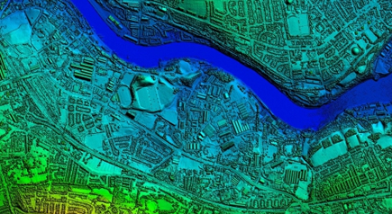
Comprehensive range of height & LiDAR data suitable for Local Authorities, Government agencies, private sector engineering, environmental & planning consultancies.
HEIGHT & LIDAR DATA
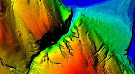
DSM Vs DTM
Supplier
Dataset Name
Resolution
Vertical Accuracy
Coverage
DTM or DSM
Data Collection Method
Environment Agency
EA LiDAR
2m-0.25m
+/- 15cm
Coastal, flood risk and urban centres
Both
LiDAR and photogrammetry
Ordnance Survey
OS Terrain 5
5m
+/- 1.5m Urban, +/- 2.5m Rural
GB
DTM
Photogrammetry, topographical survey
Ordnance Survey
OS Terrain 50
50m
+/- 4m
GB
DTM
Photogrammetry, topographical survey
Intermap
Nextmap
5m
+/- 1m
GB
Both
IFSAR
LPS
LPS OS NI
10m
+/- 1m
NI
DTM
Photogrammetry
Airbus Defence & Space
Astrium LiDAR
2m – 0.5m
+/- 15cm
100+ GB urban areas
LiDAR
LiDAR
Blom
Blom LiDAR
Up to 0.25m
+/- 15cm
London
Both
LiDAR
Cities Revealed
CR Height
2m or 1m
+/- 15cm
Numerous urban centres and environs
Both
LiDAR
Digital Surface Models (DSMs) provide a topographic model of the earth’s surface. They measure the height values of the first surface on the ground as seen from above, including terrain features, buildings, vegetation and power lines.
Digital Terrain Models (DTMs) provide a topographic model of the bare earth / underlying terrain of the earth’s surface and are usually derived from DSMs by digitally removing the man-made and vegetation features. The stated accuracy of a DTM will therefore usually be slightly lower than that of the DSM it’s derived from, particularly in areas of continuous and dense building and tree coverage.
FEATURES & BENEFITS
Our height data and LiDAR products for site landscape and topography add up to the most comprehensive online range in terms of detail and coverage.
Easy to work with, the data can be brought into CAD and GIS software to enable 3D analysis and provide important contextual information for a range of applications.
We can supply the data in six main formats, and you’ll need CAD or GIS software to open and use it:
DXF Format Points CAD
ASCII Grid for GIS
DXF 3D Face CAD
XYZ – easting, northing, height CAD/GIS
Erdas Imagine image file GIS
Contours – DXF files for CAD/GIS
In most cases an Ordnance Survey-based map or aerial imagery will be needed in order to relate the height information to geographic and topographical features.
When opened in CAD/GIS, all formats are geo-referenced with an x, y location (eastings, northings on the Ordnance Survey National Grid) making it very easy to precisely overlay height data with OS mapping products. In CAD, an insertion point of 0,0 will need to be specified if prompted by the software.
Extensive range of formats to suit a huge variety of software and applications
Vast spread of resolutions to meet any needs, from contextual overviews to advanced 3D analysis
Full product support available from our experienced technical team