
Ordnance Survey Planning Map info
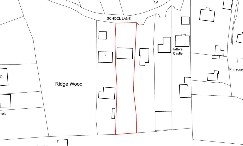
[fusion_builder_container admin_label=”” hundred_percent=”no” equal_height_columns=”no” menu_anchor=”” hide_on_mobile=”small-visibility,medium-visibility,large-visibility” class=”” id=”” background_color=”” background_image=”” background_position=”center center” background_repeat=”no-repeat” fade=”no” background_parallax=”none” enable_mobile=”no” parallax_speed=”0.3″ video_mp4=”” video_webm=”” video_ogv=”” video_url=”” video_aspect_ratio=”16:9″ video_loop=”yes” video_mute=”yes” video_preview_image=”” border_size=”” border_color=”” border_style=”solid” margin_top=”” margin_bottom=”” padding_top=”50″ padding_right=”” padding_bottom=”50″ padding_left=””][fusion_builder_row][fusion_builder_column type=”1_1″ layout=”1_1″ spacing=”” center_content=”no” hover_type=”none” link=”” min_height=”” hide_on_mobile=”small-visibility,medium-visibility,large-visibility” class=”” id=”” background_color=”” background_image=”” background_position=”left top” background_repeat=”no-repeat” border_size=”0″ border_color=”” border_style=”solid” border_position=”all” padding=”” dimension_margin=”” animation_type=”” animation_direction=”left” animation_speed=”0.3″ animation_offset=”” last=”no”][fusion_title margin_top=”” margin_bottom=”” hide_on_mobile=”small-visibility,medium-visibility,large-visibility” class=”” id=”” size=”1″ content_align=”center” style_type=”none” sep_color=””] Ordnance Survey Planning Map Info [/fusion_title][/fusion_builder_column][fusion_builder_column type=”2_3″ layout=”2_3″ spacing=”” center_content=”no” hover_type=”none” link=”” min_height=”” hide_on_mobile=”small-visibility,medium-visibility,large-visibility” class=”” id=”” background_color=”” background_image=”” background_position=”left top” background_repeat=”no-repeat” border_size=”0″ border_color=”” border_style=”solid” border_position=”all” padding=”” dimension_margin=”” animation_type=”” animation_direction=”left” animation_speed=”0.3″ animation_offset=”” last=”no”][fusion_title margin_top=”” margin_bottom=”” hide_on_mobile=”small-visibility,medium-visibility,large-visibility” class=”” id=”” size=”1″ content_align=”left” style_type=”double dashed” sep_color=””] Planning Maps – What to submit for a planning application? [/fusion_title][fusion_text] All Joanna James Planning Maps are Planning Portal & Local Planning Authority compliant. This Ordnance Survey Planning Map info will help you ensure that your Planning Application is not delayed, or rejected, by the Local Planning Authority because of discrepancies or unlicensed usage with your site location plans. From April 2015, all planning applications must include a Site Location Plan (also known as a location plan) which outlines the proposed development in it surrounding context. Some Local Authorities also require a Block Plan which can show the development in more detail. These plans enable the local planning authority (LPA) to identify the land to which the application refers and should be based upon a current Ordnance Survey map. So, use Ordnance Survey Planning Map info to help get your planning application rubber stamped as quickly as possible. [/fusion_text][/fusion_builder_column][fusion_builder_column type=”1_3″ layout=”1_3″ spacing=”” center_content=”yes” hover_type=”none” link=”” min_height=”” hide_on_mobile=”small-visibility,medium-visibility,large-visibility” class=”” id=”” background_color=”” background_image=”” background_position=”left top” undefined=”” background_repeat=”no-repeat” border_size=”0″ border_color=”” border_style=”solid” border_position=”all” padding=”40 0px 0px 0px” margin_top=”” margin_bottom=”” animation_type=”” animation_direction=”left” animation_speed=”0.3″ animation_offset=”” last=”no”][fusion_imageframe image_id=”12359″ style_type=”none” stylecolor=”” hover_type=”none” bordersize=”” bordercolor=”” borderradius=”” align=”center” lightbox=”no” gallery_id=”” lightbox_image=”” alt=”Ordnance Survey Planning Map info” link=”” linktarget=”_self” hide_on_mobile=”small-visibility,medium-visibility,large-visibility” class=”” id=”” animation_type=”” animation_direction=”left” animation_speed=”0.3″ animation_offset=””]https://joanna-james.com/wp-content/uploads/2017/02/OS-data-logo-215×200.png[/fusion_imageframe][fusion_separator style_type=”none” hide_on_mobile=”small-visibility,medium-visibility,large-visibility” class=”” id=”” sep_color=”” top_margin=”15″ bottom_margin=”15″ border_size=”” icon=”” icon_circle=”” icon_circle_color=”” width=”” alignment=”center” /][fusion_button link=”https://joanna-james.com/planning-maps/” title=”Order ordnace survey mapping for your planning application map” target=”_self” link_attributes=”” alignment=”center” modal=”” hide_on_mobile=”small-visibility,medium-visibility,large-visibility” class=”” id=”” color=”custom” button_gradient_top_color=”#4685ed” button_gradient_bottom_color=”#4685ed” button_gradient_top_color_hover=”#2979ff” button_gradient_bottom_color_hover=”#2979ff” accent_color=”#ffffff” accent_hover_color=”#ffffff” type=”” bevel_color=”” border_width=”” size=”” stretch=”default” shape=”” icon=”” icon_position=”left” icon_divider=”no” animation_type=”” animation_direction=”left” animation_speed=”0.3″ animation_offset=””]ORDER OS PLANNING MAP >[/fusion_button][/fusion_builder_column][/fusion_builder_row][/fusion_builder_container][fusion_builder_container admin_label=”” hundred_percent=”no” equal_height_columns=”no” menu_anchor=”” hide_on_mobile=”small-visibility,medium-visibility,large-visibility” class=”” id=”” background_color=”#f6f6f6″ background_image=”” background_position=”center center” background_repeat=”no-repeat” fade=”no” background_parallax=”none” enable_mobile=”no” parallax_speed=”0.3″ video_mp4=”” video_webm=”” video_ogv=”” video_url=”” video_aspect_ratio=”16:9″ video_loop=”yes” video_mute=”yes” video_preview_image=”” border_size=”” border_color=”” border_style=”solid” margin_top=”” margin_bottom=”” padding_top=”50″ padding_right=”” padding_bottom=”50″ padding_left=””][fusion_builder_row][fusion_builder_column type=”1_1″ layout=”1_1″ spacing=”” center_content=”no” hover_type=”none” link=”” min_height=”” hide_on_mobile=”small-visibility,medium-visibility,large-visibility” class=”” id=”” background_color=”” background_image=”” background_position=”left top” background_repeat=”no-repeat” border_size=”0″ border_color=”” border_style=”solid” border_position=”all” padding=”” animation_type=”” animation_direction=”left” animation_speed=”0.3″ animation_offset=”” last=”no”][fusion_title margin_top=”” margin_bottom=”” hide_on_mobile=”small-visibility,medium-visibility,large-visibility” class=”” id=”” size=”1″ content_align=”left” style_type=”double dashed” sep_color=””] Location Plans. [/fusion_title][/fusion_builder_column][fusion_builder_column type=”1_2″ layout=”1_2″ spacing=”” center_content=”no” hover_type=”none” link=”” min_height=”” hide_on_mobile=”small-visibility,medium-visibility,large-visibility” class=”” id=”” background_color=”” background_image=”” background_position=”left top” background_repeat=”no-repeat” border_size=”0″ border_color=”” border_style=”solid” border_position=”all” padding=”” dimension_margin=”” animation_type=”” animation_direction=”left” animation_speed=”0.3″ animation_offset=”” last=”no”][fusion_imageframe image_id=”11913″ style_type=”none” stylecolor=”” hover_type=”none” bordersize=”” bordercolor=”” borderradius=”” align=”none” lightbox=”no” gallery_id=”” lightbox_image=”” alt=”Ordnance Survey Planning Map info” link=”” linktarget=”_self” hide_on_mobile=”small-visibility,medium-visibility,large-visibility” class=”” id=”” animation_type=”” animation_direction=”left” animation_speed=”0.3″ animation_offset=””]https://joanna-james.com/wp-content/uploads/2016/09/planning-application-map-from-joanna-james.jpg[/fusion_imageframe][fusion_separator style_type=”none” hide_on_mobile=”small-visibility,medium-visibility,large-visibility” class=”” id=”” sep_color=”” top_margin=”15″ bottom_margin=”15″ border_size=”” icon=”” icon_circle=”” icon_circle_color=”” width=”” alignment=”center” /][fusion_button link=”https://joanna-james.com/planning-maps/” title=”Order ordnace survey mapping for your planning application map” target=”_self” link_attributes=”” alignment=”center” modal=”” hide_on_mobile=”small-visibility,medium-visibility,large-visibility” class=”” id=”” color=”custom” button_gradient_top_color=”#4685ed” button_gradient_bottom_color=”#4685ed” button_gradient_top_color_hover=”#2979ff” button_gradient_bottom_color_hover=”#2979ff” accent_color=”#f6f6f6″ accent_hover_color=”#f6f6f6″ type=”” bevel_color=”” border_width=”” size=”” stretch=”default” shape=”” icon=”” icon_position=”left” icon_divider=”no” animation_type=”” animation_direction=”left” animation_speed=”0.3″ animation_offset=””]ORDER OS PLANNING MAP >[/fusion_button][/fusion_builder_column][fusion_builder_column type=”1_2″ layout=”1_2″ spacing=”” center_content=”no” hover_type=”none” link=”” min_height=”” hide_on_mobile=”small-visibility,medium-visibility,large-visibility” class=”” id=”” background_color=”” background_image=”” background_position=”left top” background_repeat=”no-repeat” border_size=”0″ border_color=”” border_style=”solid” border_position=”all” padding=”” dimension_margin=”” animation_type=”” animation_direction=”left” animation_speed=”0.3″ animation_offset=”” last=”no”][fusion_text] Ordnance Survey Planning Map info re: Site Location Plans Must be at an identified standard metric scale (typically 1:1250 or 1:2500 for larger sites as found on Ordnance Survey mapping). Must include a North arrow and be scaled to fit on either A4 or A3 paper. Must be up to date and show the current site. Clearly identify the land to which the proposal relates (the site) and its situation in relation to the locality and in particular, neighbouring buildings and land (land which, or part of which, is contiguous or within 20 metres of the boundary of the land for which development is proposed). The site boundary shown in red including any access route up to the public highway; Other adjoining land owned by the applicant outlined in blue; Surrounding buildings should be accurately shown and numbered, or named, to ensure that the exact location of the site is clear; At least 2 named roads should be identified If the site is in the countryside, an Ordnance survey style plan at a scale of 1: 10,000 for identification purposes is generally required. Because Joanna James really care, we deliver the correct Mapping in accordance to this Ordnance Survey Planning Map info [/fusion_text][/fusion_builder_column][/fusion_builder_row][/fusion_builder_container][fusion_builder_container admin_label=”” hundred_percent=”no” equal_height_columns=”no” menu_anchor=”” hide_on_mobile=”small-visibility,medium-visibility,large-visibility” class=”” id=”” background_color=”” background_image=”” background_position=”center center” background_repeat=”no-repeat” fade=”no” background_parallax=”none” enable_mobile=”no” parallax_speed=”0.3″ video_mp4=”” video_webm=”” video_ogv=”” video_url=”” video_aspect_ratio=”16:9″ video_loop=”yes” video_mute=”yes” video_preview_image=”” border_size=”” border_color=”” border_style=”solid” margin_top=”” margin_bottom=”” padding_top=”50″ padding_right=”” padding_bottom=”” padding_left=””][fusion_builder_row][fusion_builder_column type=”1_1″ layout=”1_1″ spacing=”” center_content=”no” hover_type=”none” link=”” min_height=”” hide_on_mobile=”small-visibility,medium-visibility,large-visibility” class=”” id=”” background_color=”” background_image=”” background_position=”left top” background_repeat=”no-repeat” border_size=”0″ border_color=”” border_style=”solid” border_position=”all” padding=”” animation_type=”” animation_direction=”left” animation_speed=”0.3″ animation_offset=”” last=”no”][fusion_title margin_top=”” margin_bottom=”” hide_on_mobile=”small-visibility,medium-visibility,large-visibility” class=”” id=”” size=”1″ content_align=”left” style_type=”double dashed” sep_color=””] Block Plans. [/fusion_title][fusion_text] Some Local Planning Authorities with their Ordnance Survey Planning Map info / guidelines also require a Block Plan or Site Plan which is at a larger scale of 1:500 or 1:200 as appropriate. OS mapping at this scale does not include any greater details, but gives an opportunity to include landscaping, trees, drainage etc. These are not detailed Architects plans. They must be current Clearly outline the direction of north; Depending on LPA’s they may also require: The site boundary clearly shown in red including any access route up to the public highway; The access arrangements (this shall also include details of the visibility splays to be achieved within the applicants control) ; Landscaping (layout and planting details) ; Car parking (proposed and/or existing car parking layouts; including surfacing and how the spaces are to be delineated) ; Open areas around the buildings (how these are to be treated) ; Identify
£200. OS 3D Massing Model. Simple. Effective. Inexpensive.
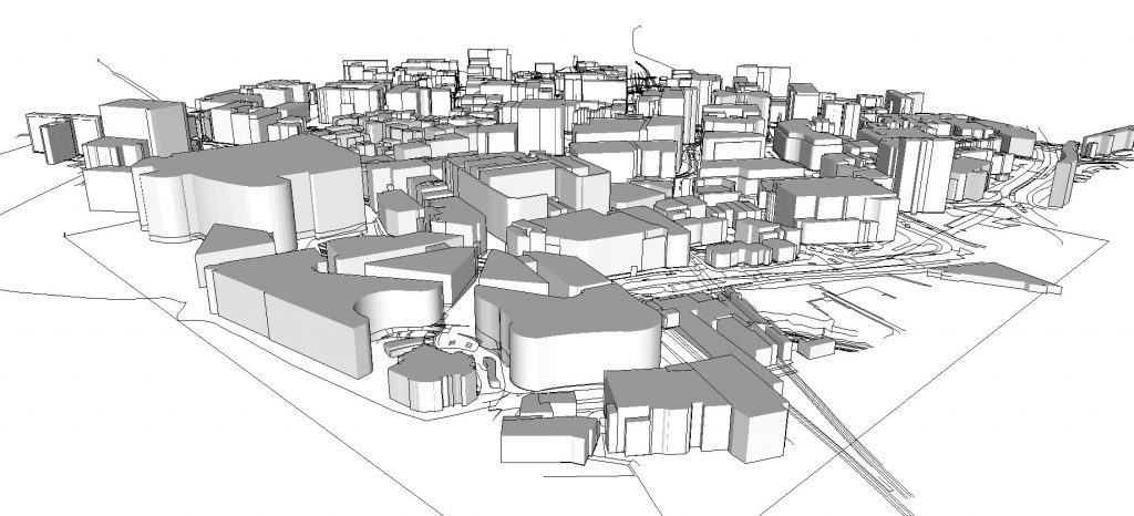
With every OS 3D Massing Model from Joanna James we include OS MasterMap, OS Terrain 5 height data & of course the 3D Model, all for one great price.
NEW Architectural 3D Models of UK available from Joanna-James.com

Priced from £250, Joanna James has partnered with Accucities to launch the most up to date 3D Models on the market, supporting projects of Architects, Civil Engineers and Planners.
Its now possible to get a 1x1km – 3D Model in 30 secs for £450!
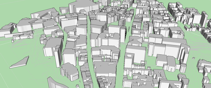
[fusion_builder_container hundred_percent=”no” equal_height_columns=”no” hide_on_mobile=”small-visibility,medium-visibility,large-visibility” background_position=”center center” background_repeat=”no-repeat” fade=”no” background_parallax=”none” parallax_speed=”0.3″ video_aspect_ratio=”16:9″ video_loop=”yes” video_mute=”yes” overlay_opacity=”0.5″ border_style=”solid”][fusion_builder_row][fusion_builder_column type=”1_1″ layout=”1_1″ background_position=”left top” background_color=”” border_size=”” border_color=”” border_style=”solid” border_position=”all” spacing=”yes” background_image=”” background_repeat=”no-repeat” padding=”” margin_top=”0px” margin_bottom=”0px” class=”” id=”” animation_type=”” animation_speed=”0.3″ animation_direction=”left” hide_on_mobile=”small-visibility,medium-visibility,large-visibility” center_content=”no” last=”no” min_height=”” hover_type=”none” link=””][fusion_text] It’s now possible to get a 1x1km – 3D Model in 30 secs for £450! That’s not possible, is it? “Start the clock” Go to Email > Download Attachement > Double Click File > Wait for Sketchup to Open…. “Stop the Clock!” 28.75 seconds. Yep, it is possible to get a ready made 3D Model for £450 in under 30 secs… I timed it on my iPhone this morning. It really is that quick & simple. For sure, you send us a request & we say max one day turnaround, but what that means is once youve sent the request in, it frees you & your team up Worked example. Take the 1km2 urban example at £450 plus vat. Our 3D Massing Models use & include OS MasterMap as a base. Alone this costs £261.99 plus vat. Therefore, split the difference, for just an extra £188.01 you can get a 1x1km simple urban 3D Massing Model that is cost effective & time saving. I can do that myself! I know you can, but these 3D Massing Models are developed to save time and money, freeing you up to do what you do best. Pride in one’s own work, I genuinely understand, plus I know that most of our clients are more than capable of putting together a simple 3D massing model. But, as a business owner I understand ROI & time spent is money spent. Often unnecessarily. I can & often do clean my own car. But for the most part I value my family time at a weekend far more. Therefore, I pay for a local firm to wash my car. Often they do it quicker, with similar if not better results. So, it is possible? 100% Yes, but… It’s horses for courses, as I’m finding here in Sunny Gold Cup Cheltenham, our hometown, as we bake in glorious weather & I continue to pick wrong uns! Seriously, 3D models come in many many forms with varying degrees of accuracy & application. The intention with the Joanna James 3D Massing Model is to help Architects, Planners, Designers & Developers get off to a flying start at pre-tender stage or adding context for visualisation purposes. That means spending the least amount of cash for the maximum return in my mind. So, yes £450 plus vat will get you a simple urban 3D Massing Model… in 30 secs. Cheers & best of luck for the racing Rob Stringer Owner, Joanna James Any questions do get in touch… rob.stringer@joanna-james.com [/fusion_text][/fusion_builder_column][/fusion_builder_row][/fusion_builder_container]