
Press Release: New Joanna James Map Portal Launched
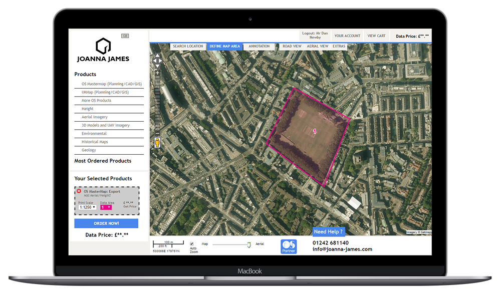
[fusion_builder_container hundred_percent=”no” equal_height_columns=”no” hide_on_mobile=”small-visibility,medium-visibility,large-visibility” background_position=”center center” background_repeat=”no-repeat” fade=”no” background_parallax=”none” parallax_speed=”0.3″ video_aspect_ratio=”16:9″ video_loop=”yes” video_mute=”yes” overlay_opacity=”0.5″ border_style=”solid”][fusion_builder_row][fusion_builder_column type=”1_1″ layout=”1_1″ background_position=”left top” background_color=”” border_size=”” border_color=”” border_style=”solid” border_position=”all” spacing=”yes” background_image=”” background_repeat=”no-repeat” padding=”” margin_top=”0px” margin_bottom=”0px” class=”” id=”” animation_type=”” animation_speed=”0.3″ animation_direction=”left” hide_on_mobile=”small-visibility,medium-visibility,large-visibility” center_content=”no” last=”no” min_height=”” hover_type=”none” link=””][fusion_title hide_on_mobile=”small-visibility,medium-visibility,large-visibility” size=”1″ content_align=”center” style_type=”default”] There’s a new girl in town: Joanna James Map Portal [/fusion_title][fusion_imageframe image_id=”12148″ style_type=”none” hover_type=”none” align=”center” lightbox=”no” alt=”Joanna James Map Portal” linktarget=”_self” hide_on_mobile=”small-visibility,medium-visibility,large-visibility” animation_direction=”left” animation_speed=”0.3″]https://joanna-james.com/wp-content/uploads/2017/01/001-MacBook-jj-homepage-1000px-300×176.png[/fusion_imageframe][fusion_text] For immediate release: 28 February 2017 There’s a new girl in town: Joanna-James.com Joanna James, a Geo-spatial data company, supports the projects of Architects, Civil Engineers and Planners providing them with access to maps and data through a 24/7 Map Portal. Users can search, locate, mark out sites, order and download a wide range of maps and data, including Ordnance Survey MasterMap, Aerial Imagery, British Geological Survey data, Height and LiDAR and 3D models of the built environment. Rob Stringer, Managing Director said: “I’m certain Joanna James will resonate well with Architects, Civil Engineers and Planners across the UK, providing good value products in a timely fashion.” Stringer further explained: “We only work with best of breed data suppliers. It’s very important to us that our customers can rely on the data supplied, enabling accurate and informed decisions to be made at all stages of a project.” The ethos of “new kid on the block” Joanna James is derived from the RIBA Plan of Work which they believe gives them a real edge when understanding their customers’ mapping and data needs. The online Joanna James Map Portal is free to sign-up, doesn’t require any software downloads or installations. It can be used on any web browser (Google Chrome, Internet Explorer, Firefox Safari) via Apple Mac or PC and works anywhere in the world 24/7. Visit and sign-up for FREE at www.joanna-james.com ## Notes to editors: For more information please contact Rob Stringer, Managing Director. Mobile: 07809535316 Phone: 01242 681140 Email: rob.stringer@joanna-james.com Website: www.joanna-james.com [/fusion_text][fusion_button link=”https://joanna-james.com/wp-content/uploads/2017/02/Press-Pack-Joanna-James-Launch.zip” title=”Press Pack Download for Joanna James launch.” target=”_self” alignment=”center” hide_on_mobile=”small-visibility,medium-visibility,large-visibility” color=”custom” button_gradient_top_color=”#4685ed” button_gradient_bottom_color=”#4685ed” button_gradient_top_color_hover=”#2979ff” button_gradient_bottom_color_hover=”#2979ff” accent_color=”#ffffff” accent_hover_color=”#ffffff” stretch=”default” icon_position=”left” icon_divider=”no” animation_direction=”left” animation_speed=”0.3″]DOWNLOAD PRESS PACK[/fusion_button][/fusion_builder_column][/fusion_builder_row][/fusion_builder_container]
We. Are. Live.
[fusion_builder_container hundred_percent=”no” equal_height_columns=”no” hide_on_mobile=”small-visibility,medium-visibility,large-visibility” background_position=”center center” background_repeat=”no-repeat” fade=”no” background_parallax=”none” parallax_speed=”0.3″ video_aspect_ratio=”16:9″ video_loop=”yes” video_mute=”yes” overlay_opacity=”0.5″ border_style=”solid”][fusion_builder_row][fusion_builder_column type=”1_1″ layout=”1_1″ background_position=”left top” background_color=”” border_size=”” border_color=”” border_style=”solid” border_position=”all” spacing=”yes” background_image=”” background_repeat=”no-repeat” padding=”” margin_top=”0px” margin_bottom=”0px” class=”” id=”” animation_type=”” animation_speed=”0.3″ animation_direction=”left” hide_on_mobile=”small-visibility,medium-visibility,large-visibility” center_content=”no” last=”no” min_height=”” hover_type=”none” link=””][fusion_imageframe image_id=”12148″ style_type=”none” hover_type=”none” align=”center” lightbox=”no” alt=”Joanna James Map Portal for Architects, Civil Engineers & Planners” link=”https://joanna-james.com/” linktarget=”_self” hide_on_mobile=”small-visibility,medium-visibility,large-visibility” animation_direction=”left” animation_speed=”0.3″]https://joanna-james.com/wp-content/uploads/2017/01/001-MacBook-jj-homepage-1000px.png[/fusion_imageframe][fusion_text] Welcome to your new Map Portal. Joanna James Map Portal is proud to announce we are live. GeoSpatial Data 24/7 for Architects, Civil Engineers & Planners. [/fusion_text][fusion_button link=”https://maps.joanna-james.com” title=”Order ordnace survey mapping, height data, aerial imagery from joanna james map portal” target=”_self” alignment=”center” hide_on_mobile=”small-visibility,medium-visibility,large-visibility” color=”custom” button_gradient_top_color=”#4685ed” button_gradient_bottom_color=”#4685ed” button_gradient_top_color_hover=”#2979ff” button_gradient_bottom_color_hover=”#2979ff” accent_color=”#ffffff” accent_hover_color=”#ffffff” stretch=”default” icon_position=”left” icon_divider=”no” animation_direction=”left” animation_speed=”0.3″]VISIT MAP PORTAL[/fusion_button][fusion_text] Architects. Civil Engineers. Planners. Joanna James Map Portal is for you. Online & free to sign-up, doesn’t require any software downloads or installations, can be used on any web browser (Google Chrome, Internet Explorer, Firefox Safari) via Apple Mac or PC and works anywhere in the world 24/7. [/fusion_text][fusion_button link=”https://maps.joanna-james.com” title=”Order ordnace survey mapping, height data, aerial imagery from joanna james map portal” target=”_self” alignment=”center” hide_on_mobile=”small-visibility,medium-visibility,large-visibility” color=”custom” button_gradient_top_color=”#4685ed” button_gradient_bottom_color=”#4685ed” button_gradient_top_color_hover=”#2979ff” button_gradient_bottom_color_hover=”#2979ff” accent_color=”#ffffff” accent_hover_color=”#ffffff” stretch=”default” icon_position=”left” icon_divider=”no” animation_direction=”left” animation_speed=”0.3″]JOIN FREE[/fusion_button][fusion_text] The new girl in town: Joanna James. Users can search, locate, mark out sites, order & download a wide range of maps & data. Including Ordnance Survey MasterMap, Aerial Imagery, British Geological Survey data, Height & LiDAR & 3D models of the built environment. [/fusion_text][fusion_button link=”https://maps.joanna-james.com” title=”Order ordnace survey mapping, height data, aerial imagery from joanna james map portal” target=”_self” alignment=”center” hide_on_mobile=”small-visibility,medium-visibility,large-visibility” color=”custom” button_gradient_top_color=”#4685ed” button_gradient_bottom_color=”#4685ed” button_gradient_top_color_hover=”#2979ff” button_gradient_bottom_color_hover=”#2979ff” accent_color=”#ffffff” accent_hover_color=”#ffffff” stretch=”default” icon_position=”left” icon_divider=”no” animation_direction=”left” animation_speed=”0.3″]PRODUCTS[/fusion_button][fusion_text] Proud to be closely associated. Joanna-James.com Map Portal. Proudly powered by Ordnance Survey Data. [/fusion_text][fusion_imageframe image_id=”12359″ style_type=”none” hover_type=”none” align=”center” lightbox=”no” alt=”Joanna James Map Portal powered by Ordnance Survey” link=”https://joanna-james.com/” linktarget=”_self” hide_on_mobile=”small-visibility,medium-visibility,large-visibility” animation_direction=”left” animation_speed=”0.3″]https://joanna-james.com/wp-content/uploads/2017/02/OS-data-logo-215×200.png[/fusion_imageframe][/fusion_builder_column][/fusion_builder_row][/fusion_builder_container]
Coming Soon Joanna James Map Portal

Joanna James Map Portal – Coming very soon! Calling all Architects, Civil Engineers & Planners….. Are you ready? The Joanna James Map Portal is about to launch. It’s just a matter of days away. Joanna James is a GeoSpatial data company, supporting the projects of Architects, Civil Engineers and Planners providing access to maps and data through a 24/7 Map Portal (….that’s not quite ready just yet, but give us a couple of days!) Users can quickly access wide range of maps and data, including Ordnance Survey MasterMap, Aerial Imagery, British Geological Survey data, Height and LiDAR and 3D models of the built environment. We’ll keep you posted when we fully launch. Any immediate enquiries are welcomed: info@joanna-james.com