LAUNCHED – 25km2 3D Model of London
[fusion_builder_container hundred_percent=”no” equal_height_columns=”no” hide_on_mobile=”small-visibility,medium-visibility,large-visibility” background_position=”center center” background_repeat=”no-repeat” fade=”no” background_parallax=”none” parallax_speed=”0.3″ video_aspect_ratio=”16:9″ video_loop=”yes” video_mute=”yes” border_style=”solid”][fusion_builder_row][fusion_builder_column type=”1_1″ layout=”1_1″ background_position=”left top” background_color=”” border_size=”” border_color=”” border_style=”solid” border_position=”all” spacing=”yes” background_image=”” background_repeat=”no-repeat” padding=”” margin_top=”0px” margin_bottom=”0px” class=”” id=”” animation_type=”” animation_speed=”0.3″ animation_direction=”left” hide_on_mobile=”small-visibility,medium-visibility,large-visibility” center_content=”no” last=”no” min_height=”” hover_type=”none” link=””][fusion_title margin_top=”” margin_bottom=”” hide_on_mobile=”small-visibility,medium-visibility,large-visibility” class=”” id=”” size=”1″ content_align=”center” style_type=”none” sep_color=””] LAUNCHED – 25km2 3D Model of London [/fusion_title][/fusion_builder_column][fusion_builder_column type=”1_1″ layout=”1_1″ spacing=”” center_content=”no” hover_type=”none” link=”” min_height=”” hide_on_mobile=”small-visibility,medium-visibility,large-visibility” class=”” id=”” background_color=”” background_image=”” background_position=”left top” background_repeat=”no-repeat” border_size=”0″ border_color=”” border_style=”solid” border_position=”all” padding=”” dimension_margin=”” animation_type=”” animation_direction=”left” animation_speed=”0.3″ animation_offset=”” last=”no”][fusion_text] Subscribe & Save £1000s HUGE ANNOUNCEMENT: 25km² 3D Model of London Subscription is LIVE & will save our clients £1000s. If you are currently spending more than £1000 per month on 3D Models of London then a subscription to 25km2 London 3D Model from Joanna James this is for you! High Detail 3D Model of London 25km² High Detail 3D Model of London is captured from the latest 2016 High-Res imagery. The 3D Model will be continuously updated & upgraded and will be enlarged to cover 40km² throughout 2018. The dataset is available as AutoCad, SketchUp or .FBX files. For state-of the-art presentations and simulations, this 3D Model of London is also supplied imported into Unreal Engine 4. Our High Detail 3D Model of London now includes Future City Skyline layer. £1000 + VAT / month / 36 months subscription. Find out more > “How much do you spend on 3D Models per month?” We’ve kept things simple simple. The subscription service works very similar to Spotify vs iTunes. Music customers now benefit hugely from subscribing to music subscription services & can listen to an unlimited number of songs each month for one clear price. Whereas before this, customers had to buy each and every song or album at a significantly greater expense each month. This London 3D Model subscription service does exactly the same as a music subscription service and represents a real step change for architects, planners and civil engineers who have one eye on quality & the other on expenditure. FREE expansion from 25km² to 40km² early 2018. Subscribe to High Detail 3D Model now to get the 25km² to 40km² upgrade absolutely free. See below for details of the intended expansion: Subscription 3D Models of London | Watch Introduction Video | Download Samples [/fusion_text][/fusion_builder_column][/fusion_builder_row][/fusion_builder_container][fusion_builder_container hundred_percent=”no” equal_height_columns=”no” menu_anchor=”” hide_on_mobile=”small-visibility,medium-visibility,large-visibility” class=”” id=”” background_color=”” background_image=”” background_position=”center center” background_repeat=”no-repeat” fade=”no” background_parallax=”none” enable_mobile=”no” parallax_speed=”0.3″ video_mp4=”” video_webm=”” video_ogv=”” video_url=”” video_aspect_ratio=”16:9″ video_loop=”yes” video_mute=”yes” video_preview_image=”” border_size=”” border_color=”” border_style=”solid” margin_top=”” margin_bottom=”” padding_top=”” padding_right=”” padding_bottom=”” padding_left=””][fusion_builder_row][fusion_builder_column type=”1_4″ layout=”1_1″ spacing=”” center_content=”no” hover_type=”none” link=”” min_height=”” hide_on_mobile=”small-visibility,medium-visibility,large-visibility” class=”” id=”” background_color=”” background_image=”” background_position=”left top” background_repeat=”no-repeat” border_size=”0″ border_color=”” border_style=”solid” border_position=”all” padding=”” dimension_margin=”” animation_type=”” animation_direction=”left” animation_speed=”0.3″ animation_offset=”” last=”no”][/fusion_builder_column][fusion_builder_column type=”1_4″ layout=”1_1″ spacing=”” center_content=”no” hover_type=”none” link=”” min_height=”” hide_on_mobile=”small-visibility,medium-visibility,large-visibility” class=”” id=”” background_color=”” background_image=”” background_position=”left top” background_repeat=”no-repeat” border_size=”0″ border_color=”” border_style=”solid” border_position=”all” padding=”” dimension_margin=”” animation_type=”” animation_direction=”left” animation_speed=”0.3″ animation_offset=”” last=”no”][fusion_button link=”https://joanna-james.com/3d-models/london-3d-model-subscription/” title=”Get more info on 3D Models from Joanna James” target=”_self” link_attributes=”” alignment=”center” modal=”” hide_on_mobile=”small-visibility,medium-visibility,large-visibility” class=”” id=”” color=”custom” button_gradient_top_color=”#4685ed” button_gradient_bottom_color=”#4685ed” button_gradient_top_color_hover=”#2979ff” button_gradient_bottom_color_hover=”#2979ff” accent_color=”#ffffff” accent_hover_color=”#ffffff” type=”” bevel_color=”” border_width=”” size=”” stretch=”default” shape=”” icon=”” icon_position=”left” icon_divider=”no” animation_type=”” animation_direction=”left” animation_speed=”0.3″ animation_offset=””]LEARN MORE[/fusion_button][/fusion_builder_column][fusion_builder_column type=”1_4″ layout=”1_1″ spacing=”” center_content=”no” hover_type=”none” link=”” min_height=”” hide_on_mobile=”small-visibility,medium-visibility,large-visibility” class=”” id=”” background_color=”” background_image=”” background_position=”left top” background_repeat=”no-repeat” border_size=”0″ border_color=”” border_style=”solid” border_position=”all” padding=”” dimension_margin=”” animation_type=”” animation_direction=”left” animation_speed=”0.3″ animation_offset=”” last=”no”][fusion_button link=”mailto:info@joanna-james.com” title=”Ask for more info about Subscription to 3D Models from Joanna James” target=”_self” link_attributes=”” alignment=”center” modal=”” hide_on_mobile=”small-visibility,medium-visibility,large-visibility” class=”” id=”” color=”custom” button_gradient_top_color=”#4685ed” button_gradient_bottom_color=”#4685ed” button_gradient_top_color_hover=”#2979ff” button_gradient_bottom_color_hover=”#2979ff” accent_color=”#ffffff” accent_hover_color=”#ffffff” type=”” bevel_color=”” border_width=”” size=”” stretch=”default” shape=”” icon=”” icon_position=”left” icon_divider=”no” animation_type=”” animation_direction=”left” animation_speed=”0.3″ animation_offset=””]ENQUIRE[/fusion_button][/fusion_builder_column][fusion_builder_column type=”1_4″ layout=”1_1″ spacing=”” center_content=”no” hover_type=”none” link=”” min_height=”” hide_on_mobile=”small-visibility,medium-visibility,large-visibility” class=”” id=”” background_color=”” background_image=”” background_position=”left top” background_repeat=”no-repeat” border_size=”0″ border_color=”” border_style=”solid” border_position=”all” padding=”” dimension_margin=”” animation_type=”” animation_direction=”left” animation_speed=”0.3″ animation_offset=”” last=”no”][/fusion_builder_column][/fusion_builder_row][/fusion_builder_container]
Stunning 3D Model of London
3D Models. Simply Stunning. 3D models in various Formats, Levels of Detail & Accuracy to fit within existing production lines. Customers can select any area of the UK, we will produce a quote for 3D Model. In London, we offer 3D Models from our library from as little as £250 / 0.5 km2 tiles. Customers can also buy 25 km2 Base 3D Model or subscribe to access always updated, high detail wide area 3D model of London. 3D data is delivered as AutoCad, SketchUp, FBX or Unreal Engine 4 app. Clients of Joanna James 3D Models include Architects, Civil Engineers & Planners. LEARN MORE Make Enquiry
How To Register? – Joanna James Map Portal
[fusion_builder_container hundred_percent=”no” equal_height_columns=”no” hide_on_mobile=”small-visibility,medium-visibility,large-visibility” background_position=”center center” background_repeat=”no-repeat” fade=”no” background_parallax=”none” parallax_speed=”0.3″ video_aspect_ratio=”16:9″ video_loop=”yes” video_mute=”yes” border_style=”solid”][fusion_builder_row][fusion_builder_column type=”1_1″ layout=”1_1″ background_position=”left top” background_color=”” border_size=”” border_color=”” border_style=”solid” border_position=”all” spacing=”yes” background_image=”” background_repeat=”no-repeat” padding=”” margin_top=”0px” margin_bottom=”0px” class=”” id=”” animation_type=”” animation_speed=”0.3″ animation_direction=”left” hide_on_mobile=”small-visibility,medium-visibility,large-visibility” center_content=”no” last=”no” min_height=”” hover_type=”none” link=””][fusion_title margin_top=”” margin_bottom=”” hide_on_mobile=”small-visibility,medium-visibility,large-visibility” class=”” id=”” size=”1″ content_align=”center” style_type=”none” sep_color=””] Video – “How to Register?” Joanna James Map Portal. [/fusion_title][fusion_text] The Joanna James Map Portal is great for accessing inexpensive, digital construction data such as Ordnance Survey MasterMap, Aerial Imagery, Height & LiDAR. Here’s how simple it is to get started… [/fusion_text][fusion_separator style_type=”single solid” hide_on_mobile=”small-visibility,medium-visibility,large-visibility” class=”” id=”” sep_color=”#ffffff” top_margin=”20″ bottom_margin=”20″ border_size=”” icon=”” icon_circle=”” icon_circle_color=”” width=”” alignment=”center” /][fusion_youtube id=”https://www.youtube.com/watch?v=bV_LG2ZNv3g&t” alignment=”center” width=”” height=”” autoplay=”true” api_params=”” hide_on_mobile=”small-visibility,medium-visibility,large-visibility” class=”” /][fusion_separator style_type=”single solid” hide_on_mobile=”small-visibility,medium-visibility,large-visibility” class=”” id=”” sep_color=”#ffffff” top_margin=”20″ bottom_margin=”20″ border_size=”” icon=”” icon_circle=”” icon_circle_color=”” width=”” alignment=”center” /][fusion_button link=”https://joanna-james.com/map-portal/” title=”Order ordnace survey mapping, height data, aerial imagery from joanna james map portal” target=”_self” link_attributes=”” alignment=”center” modal=”” hide_on_mobile=”small-visibility,medium-visibility,large-visibility” class=”” id=”” color=”custom” button_gradient_top_color=”#4685ed” button_gradient_bottom_color=”#4685ed” button_gradient_top_color_hover=”#2979ff” button_gradient_bottom_color_hover=”#2979ff” accent_color=”#ffffff” accent_hover_color=”#ffffff” type=”” bevel_color=”” border_width=”” size=”” stretch=”default” shape=”” icon=”” icon_position=”left” icon_divider=”no” animation_type=”” animation_direction=”left” animation_speed=”0.3″ animation_offset=””]MAP PORTAL >[/fusion_button][/fusion_builder_column][/fusion_builder_row][/fusion_builder_container]
Ordnance Survey Planning Map info
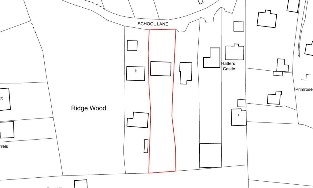
[fusion_builder_container admin_label=”” hundred_percent=”no” equal_height_columns=”no” menu_anchor=”” hide_on_mobile=”small-visibility,medium-visibility,large-visibility” class=”” id=”” background_color=”” background_image=”” background_position=”center center” background_repeat=”no-repeat” fade=”no” background_parallax=”none” enable_mobile=”no” parallax_speed=”0.3″ video_mp4=”” video_webm=”” video_ogv=”” video_url=”” video_aspect_ratio=”16:9″ video_loop=”yes” video_mute=”yes” video_preview_image=”” border_size=”” border_color=”” border_style=”solid” margin_top=”” margin_bottom=”” padding_top=”50″ padding_right=”” padding_bottom=”50″ padding_left=””][fusion_builder_row][fusion_builder_column type=”1_1″ layout=”1_1″ spacing=”” center_content=”no” hover_type=”none” link=”” min_height=”” hide_on_mobile=”small-visibility,medium-visibility,large-visibility” class=”” id=”” background_color=”” background_image=”” background_position=”left top” background_repeat=”no-repeat” border_size=”0″ border_color=”” border_style=”solid” border_position=”all” padding=”” dimension_margin=”” animation_type=”” animation_direction=”left” animation_speed=”0.3″ animation_offset=”” last=”no”][fusion_title margin_top=”” margin_bottom=”” hide_on_mobile=”small-visibility,medium-visibility,large-visibility” class=”” id=”” size=”1″ content_align=”center” style_type=”none” sep_color=””] Ordnance Survey Planning Map Info [/fusion_title][/fusion_builder_column][fusion_builder_column type=”2_3″ layout=”2_3″ spacing=”” center_content=”no” hover_type=”none” link=”” min_height=”” hide_on_mobile=”small-visibility,medium-visibility,large-visibility” class=”” id=”” background_color=”” background_image=”” background_position=”left top” background_repeat=”no-repeat” border_size=”0″ border_color=”” border_style=”solid” border_position=”all” padding=”” dimension_margin=”” animation_type=”” animation_direction=”left” animation_speed=”0.3″ animation_offset=”” last=”no”][fusion_title margin_top=”” margin_bottom=”” hide_on_mobile=”small-visibility,medium-visibility,large-visibility” class=”” id=”” size=”1″ content_align=”left” style_type=”double dashed” sep_color=””] Planning Maps – What to submit for a planning application? [/fusion_title][fusion_text] All Joanna James Planning Maps are Planning Portal & Local Planning Authority compliant. This Ordnance Survey Planning Map info will help you ensure that your Planning Application is not delayed, or rejected, by the Local Planning Authority because of discrepancies or unlicensed usage with your site location plans. From April 2015, all planning applications must include a Site Location Plan (also known as a location plan) which outlines the proposed development in it surrounding context. Some Local Authorities also require a Block Plan which can show the development in more detail. These plans enable the local planning authority (LPA) to identify the land to which the application refers and should be based upon a current Ordnance Survey map. So, use Ordnance Survey Planning Map info to help get your planning application rubber stamped as quickly as possible. [/fusion_text][/fusion_builder_column][fusion_builder_column type=”1_3″ layout=”1_3″ spacing=”” center_content=”yes” hover_type=”none” link=”” min_height=”” hide_on_mobile=”small-visibility,medium-visibility,large-visibility” class=”” id=”” background_color=”” background_image=”” background_position=”left top” undefined=”” background_repeat=”no-repeat” border_size=”0″ border_color=”” border_style=”solid” border_position=”all” padding=”40 0px 0px 0px” margin_top=”” margin_bottom=”” animation_type=”” animation_direction=”left” animation_speed=”0.3″ animation_offset=”” last=”no”][fusion_imageframe image_id=”12359″ style_type=”none” stylecolor=”” hover_type=”none” bordersize=”” bordercolor=”” borderradius=”” align=”center” lightbox=”no” gallery_id=”” lightbox_image=”” alt=”Ordnance Survey Planning Map info” link=”” linktarget=”_self” hide_on_mobile=”small-visibility,medium-visibility,large-visibility” class=”” id=”” animation_type=”” animation_direction=”left” animation_speed=”0.3″ animation_offset=””]https://joanna-james.com/wp-content/uploads/2017/02/OS-data-logo-215×200.png[/fusion_imageframe][fusion_separator style_type=”none” hide_on_mobile=”small-visibility,medium-visibility,large-visibility” class=”” id=”” sep_color=”” top_margin=”15″ bottom_margin=”15″ border_size=”” icon=”” icon_circle=”” icon_circle_color=”” width=”” alignment=”center” /][fusion_button link=”https://joanna-james.com/planning-maps/” title=”Order ordnace survey mapping for your planning application map” target=”_self” link_attributes=”” alignment=”center” modal=”” hide_on_mobile=”small-visibility,medium-visibility,large-visibility” class=”” id=”” color=”custom” button_gradient_top_color=”#4685ed” button_gradient_bottom_color=”#4685ed” button_gradient_top_color_hover=”#2979ff” button_gradient_bottom_color_hover=”#2979ff” accent_color=”#ffffff” accent_hover_color=”#ffffff” type=”” bevel_color=”” border_width=”” size=”” stretch=”default” shape=”” icon=”” icon_position=”left” icon_divider=”no” animation_type=”” animation_direction=”left” animation_speed=”0.3″ animation_offset=””]ORDER OS PLANNING MAP >[/fusion_button][/fusion_builder_column][/fusion_builder_row][/fusion_builder_container][fusion_builder_container admin_label=”” hundred_percent=”no” equal_height_columns=”no” menu_anchor=”” hide_on_mobile=”small-visibility,medium-visibility,large-visibility” class=”” id=”” background_color=”#f6f6f6″ background_image=”” background_position=”center center” background_repeat=”no-repeat” fade=”no” background_parallax=”none” enable_mobile=”no” parallax_speed=”0.3″ video_mp4=”” video_webm=”” video_ogv=”” video_url=”” video_aspect_ratio=”16:9″ video_loop=”yes” video_mute=”yes” video_preview_image=”” border_size=”” border_color=”” border_style=”solid” margin_top=”” margin_bottom=”” padding_top=”50″ padding_right=”” padding_bottom=”50″ padding_left=””][fusion_builder_row][fusion_builder_column type=”1_1″ layout=”1_1″ spacing=”” center_content=”no” hover_type=”none” link=”” min_height=”” hide_on_mobile=”small-visibility,medium-visibility,large-visibility” class=”” id=”” background_color=”” background_image=”” background_position=”left top” background_repeat=”no-repeat” border_size=”0″ border_color=”” border_style=”solid” border_position=”all” padding=”” animation_type=”” animation_direction=”left” animation_speed=”0.3″ animation_offset=”” last=”no”][fusion_title margin_top=”” margin_bottom=”” hide_on_mobile=”small-visibility,medium-visibility,large-visibility” class=”” id=”” size=”1″ content_align=”left” style_type=”double dashed” sep_color=””] Location Plans. [/fusion_title][/fusion_builder_column][fusion_builder_column type=”1_2″ layout=”1_2″ spacing=”” center_content=”no” hover_type=”none” link=”” min_height=”” hide_on_mobile=”small-visibility,medium-visibility,large-visibility” class=”” id=”” background_color=”” background_image=”” background_position=”left top” background_repeat=”no-repeat” border_size=”0″ border_color=”” border_style=”solid” border_position=”all” padding=”” dimension_margin=”” animation_type=”” animation_direction=”left” animation_speed=”0.3″ animation_offset=”” last=”no”][fusion_imageframe image_id=”11913″ style_type=”none” stylecolor=”” hover_type=”none” bordersize=”” bordercolor=”” borderradius=”” align=”none” lightbox=”no” gallery_id=”” lightbox_image=”” alt=”Ordnance Survey Planning Map info” link=”” linktarget=”_self” hide_on_mobile=”small-visibility,medium-visibility,large-visibility” class=”” id=”” animation_type=”” animation_direction=”left” animation_speed=”0.3″ animation_offset=””]https://joanna-james.com/wp-content/uploads/2016/09/planning-application-map-from-joanna-james.jpg[/fusion_imageframe][fusion_separator style_type=”none” hide_on_mobile=”small-visibility,medium-visibility,large-visibility” class=”” id=”” sep_color=”” top_margin=”15″ bottom_margin=”15″ border_size=”” icon=”” icon_circle=”” icon_circle_color=”” width=”” alignment=”center” /][fusion_button link=”https://joanna-james.com/planning-maps/” title=”Order ordnace survey mapping for your planning application map” target=”_self” link_attributes=”” alignment=”center” modal=”” hide_on_mobile=”small-visibility,medium-visibility,large-visibility” class=”” id=”” color=”custom” button_gradient_top_color=”#4685ed” button_gradient_bottom_color=”#4685ed” button_gradient_top_color_hover=”#2979ff” button_gradient_bottom_color_hover=”#2979ff” accent_color=”#f6f6f6″ accent_hover_color=”#f6f6f6″ type=”” bevel_color=”” border_width=”” size=”” stretch=”default” shape=”” icon=”” icon_position=”left” icon_divider=”no” animation_type=”” animation_direction=”left” animation_speed=”0.3″ animation_offset=””]ORDER OS PLANNING MAP >[/fusion_button][/fusion_builder_column][fusion_builder_column type=”1_2″ layout=”1_2″ spacing=”” center_content=”no” hover_type=”none” link=”” min_height=”” hide_on_mobile=”small-visibility,medium-visibility,large-visibility” class=”” id=”” background_color=”” background_image=”” background_position=”left top” background_repeat=”no-repeat” border_size=”0″ border_color=”” border_style=”solid” border_position=”all” padding=”” dimension_margin=”” animation_type=”” animation_direction=”left” animation_speed=”0.3″ animation_offset=”” last=”no”][fusion_text] Ordnance Survey Planning Map info re: Site Location Plans Must be at an identified standard metric scale (typically 1:1250 or 1:2500 for larger sites as found on Ordnance Survey mapping). Must include a North arrow and be scaled to fit on either A4 or A3 paper. Must be up to date and show the current site. Clearly identify the land to which the proposal relates (the site) and its situation in relation to the locality and in particular, neighbouring buildings and land (land which, or part of which, is contiguous or within 20 metres of the boundary of the land for which development is proposed). The site boundary shown in red including any access route up to the public highway; Other adjoining land owned by the applicant outlined in blue; Surrounding buildings should be accurately shown and numbered, or named, to ensure that the exact location of the site is clear; At least 2 named roads should be identified If the site is in the countryside, an Ordnance survey style plan at a scale of 1: 10,000 for identification purposes is generally required. Because Joanna James really care, we deliver the correct Mapping in accordance to this Ordnance Survey Planning Map info [/fusion_text][/fusion_builder_column][/fusion_builder_row][/fusion_builder_container][fusion_builder_container admin_label=”” hundred_percent=”no” equal_height_columns=”no” menu_anchor=”” hide_on_mobile=”small-visibility,medium-visibility,large-visibility” class=”” id=”” background_color=”” background_image=”” background_position=”center center” background_repeat=”no-repeat” fade=”no” background_parallax=”none” enable_mobile=”no” parallax_speed=”0.3″ video_mp4=”” video_webm=”” video_ogv=”” video_url=”” video_aspect_ratio=”16:9″ video_loop=”yes” video_mute=”yes” video_preview_image=”” border_size=”” border_color=”” border_style=”solid” margin_top=”” margin_bottom=”” padding_top=”50″ padding_right=”” padding_bottom=”” padding_left=””][fusion_builder_row][fusion_builder_column type=”1_1″ layout=”1_1″ spacing=”” center_content=”no” hover_type=”none” link=”” min_height=”” hide_on_mobile=”small-visibility,medium-visibility,large-visibility” class=”” id=”” background_color=”” background_image=”” background_position=”left top” background_repeat=”no-repeat” border_size=”0″ border_color=”” border_style=”solid” border_position=”all” padding=”” animation_type=”” animation_direction=”left” animation_speed=”0.3″ animation_offset=”” last=”no”][fusion_title margin_top=”” margin_bottom=”” hide_on_mobile=”small-visibility,medium-visibility,large-visibility” class=”” id=”” size=”1″ content_align=”left” style_type=”double dashed” sep_color=””] Block Plans. [/fusion_title][fusion_text] Some Local Planning Authorities with their Ordnance Survey Planning Map info / guidelines also require a Block Plan or Site Plan which is at a larger scale of 1:500 or 1:200 as appropriate. OS mapping at this scale does not include any greater details, but gives an opportunity to include landscaping, trees, drainage etc. These are not detailed Architects plans. They must be current Clearly outline the direction of north; Depending on LPA’s they may also require: The site boundary clearly shown in red including any access route up to the public highway; The access arrangements (this shall also include details of the visibility splays to be achieved within the applicants control) ; Landscaping (layout and planting details) ; Car parking (proposed and/or existing car parking layouts; including surfacing and how the spaces are to be delineated) ; Open areas around the buildings (how these are to be treated) ; Identify