
Planning Permission Visuals Explained for Developers
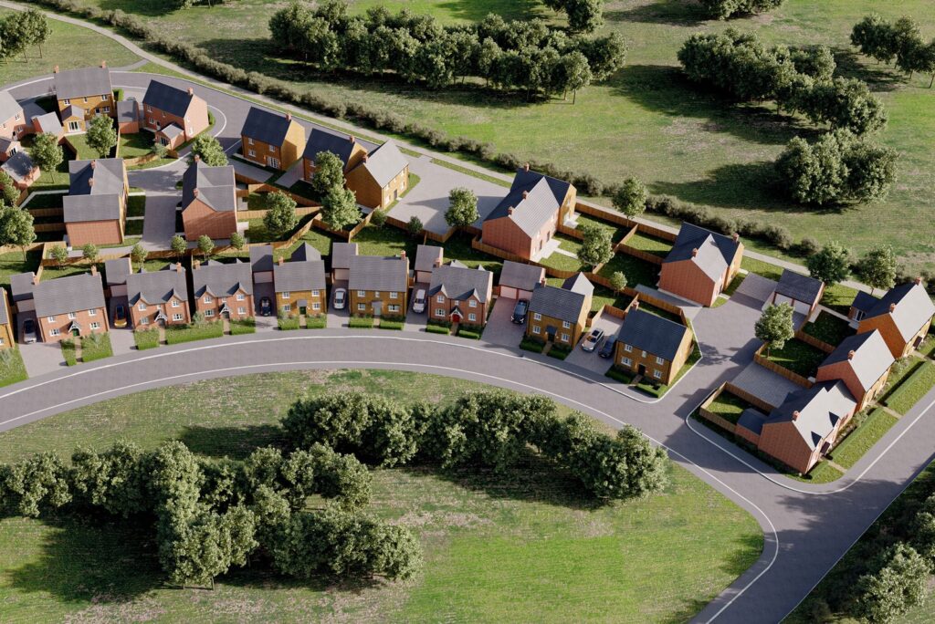
CGI visualisations for planning applications help developers show how a proposed scheme will look before construction begins. They make design intent, scale, massing, materials and surrounding conditions easier to understand. For UK development teams, strong planning permission visuals are not just presentation assets. They support design discussions, consultant feedback, local authority review, public consultation and planning committee material. When created from reliable drawings, mapping, survey inputs and 3D data, CGI visuals can reduce ambiguity and help the proposal speak clearly. What are CGI visualisations for planning applications? CGI visualisations for planning applications are digital images that show a proposed development in a realistic, project specific setting. They are usually created from architectural drawings, 3D models, site photographs, material references and mapping data. The output may be a standard architectural render, a photomontage, a verified view, a streetscene image or a set of townscape visuals. For developers, the purpose is simple: make the proposal easier to assess. A well prepared visual can show height, scale, access, façade treatment, roof form, landscaping and neighbouring relationships more clearly than plans alone. These visuals are often used alongside design and access statements, planning statements, consultation boards and local authority submissions. Why do developers use CGI visuals for planning permission? Developers use CGI visuals because planning decisions often depend on how clearly a scheme’s impact can be understood. Drawings provide the technical foundation. Visuals help non technical and technical audiences see how the proposed building, extension or wider development may appear in context. This is particularly useful where there are concerns around massing, overlooking, heritage setting, street character, landscape impact or public views. For example, a residential infill scheme may need to show how its height relates to adjoining houses. A commercial development may need to explain frontage, access and public realm changes. A larger mixed use scheme may require townscape visuals or LVIA visuals to support wider assessment work. This is where CGI Visualisations become commercially valuable. They help developers, architects, planning consultants and project teams communicate a proposal with more precision. What makes a planning CGI effective? An effective planning CGI is accurate, restrained and based on the right source information. The image should not exaggerate the design, hide important constraints or use unrealistic lighting to make the proposal appear more favourable. It should show the scheme clearly and honestly, using reliable design data and appropriate viewpoints. Key factors include: Accurate model scaleThe proposed building should be modelled from current architectural drawings, CAD files, Revit models, SketchUp files or other agreed design information. Correct viewpoint selectionCamera positions should reflect the planning purpose. This may include street level views, neighbouring property views, public realm views or agreed assessment points. Reliable surrounding detailExisting buildings, boundaries, trees, roads, pavements, levels and landscape features should be shown where they influence understanding. Consistent material representationBrick, glass, cladding, roof finishes, hard landscaping and soft landscaping should reflect the current design intent. Clear planning useA CGI for marketing may be more atmospheric. A CGI for a planning submission should be more controlled, balanced and evidence led. Where needed, Joanna James can support the visual workflow with 3D Models, mapping data, aerial imagery and survey-based inputs. Do councils require verified views? Councils do not require verified views for every application but they may be requested where visual impact, height, heritage setting or townscape sensitivity is important. A verified view is more technically controlled than a standard CGI. It normally uses surveyed camera positions, lens information, accurate model placement and agreed methodology to show how a proposal would appear from a specific viewpoint. Verified photomontages are common on schemes where the visual relationship between the proposed development and existing surroundings needs careful assessment. This can include tall buildings, dense urban sites, sensitive landscapes, conservation areas, listed building settings or prominent public viewpoints. Developers should check expectations early with their planning consultant or local authority. The article should not assume every scheme needs this level of evidence. On smaller or lower risk projects, standard CGI renders or contextual photomontages may be sufficient. For wider policy and application context, teams can refer to GOV.UK planning permission guidance. When should developers use photomontages, townscape visuals or LVIA visuals? Developers should use the format that matches the visual risk and the decision making process. A photomontage combines a proposed 3D model with real site photography. It is useful when the scheme must be shown from a recognisable viewpoint, such as a street, neighbouring land, public footpath or key approach route. Townscape visuals are used where the proposal affects the character, scale or composition of a wider built environment. They are common in urban development, regeneration, mixed use schemes and sites near sensitive architectural settings. LVIA visuals support landscape and visual impact assessment. They are more relevant for schemes where the visual relationship with landscape character, open views or rural setting needs structured assessment. A developer should not choose the output based only on visual appeal. The correct format depends on planning risk, local authority expectations, consultant advice and the level of evidence needed. What technical inputs improve accuracy? Accurate CGI starts with reliable project data. For most schemes, the visualisation team will need current elevations, plans, sections, material notes, site photographs and any available 3D design files. Better inputs usually reduce interpretation and revision time. Useful technical sources can include: CAD or DWG drawings Revit or SketchUp models FBX or other 3D model exports OS mapping OS MasterMap Measured survey data Topographical survey information LiDAR data Aerial photography GIS layers Site photography Material schedules For mapping and ground reference, OS Mapping can help establish surrounding buildings, boundaries, access routes and wider site relationships. Ordnance Survey’s own product information for Ordnance Survey MasterMap also explains its role as detailed topographic data for built and natural features.Where existing buildings are central to the scheme, Measured Building Surveys can support more dependable modelling. This is especially useful for redevelopment, extensions, façade changes, heritage work or sites where existing structure and levels matter. How do planning consultants use CGI
How CGI Site Plans Support New Housing Developments
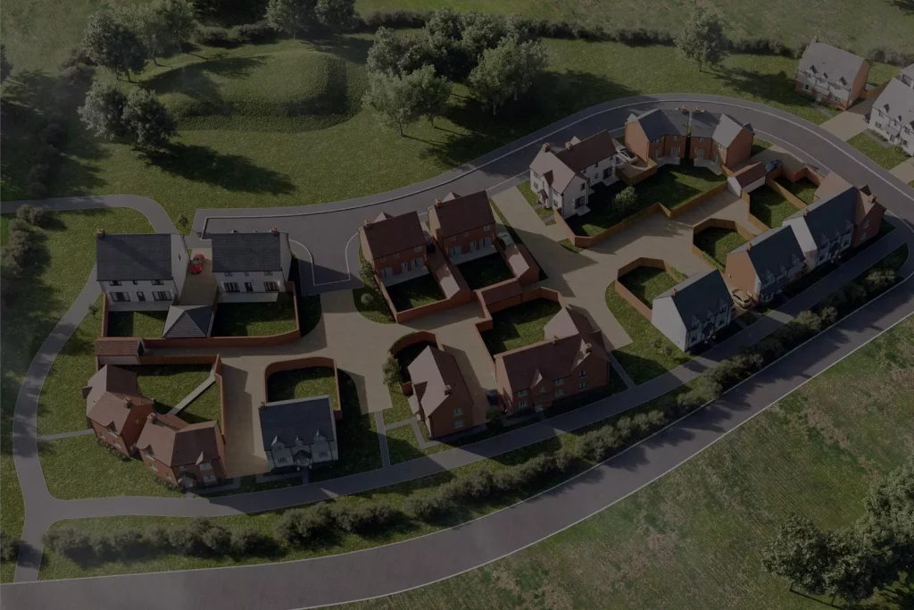
Unclear site layouts can slow decisions. A proposed housing scheme may be technically sound, yet still difficult for planning officers, landowners, residents or investors to understand from drawings alone. CGI site plans for housing developments help translate technical information into a visual format that supports planning, consultation, design review and developer presentations. When they are built from accurate mapping, survey information and current design files, they give project teams a clearer view of access, levels, plot layout, landscaping and surrounding context before work begins on site. What a CGI Site Plan Does for a Housing Scheme A CGI site plan shows how a proposed residential scheme is arranged across a site. It can present homes, roads, parking, footpaths, open space, retained features, planting, boundaries, neighbouring buildings and access routes in one clear visual. This helps different project stakeholders assess the same proposal without relying only on technical drawings. For developers, the value is practical. A strong visual can help explain density, movement, land use and design intent during early stage feasibility, planning discussions, public consultation and sales preparation. For architects and planning consultants, it can support clearer communication with clients, local authorities and wider project teams. The aim is not decoration. The aim is to reduce misunderstanding. Joanna James supports planning and development teams through CGI Visualisations for built-environment projects where clarity, scale and site context matter. How CGI Site Plans Fit Into the Planning Process CGI site plans can support planning work by making the proposed layout easier to interpret. A planning application still depends on formal drawings, reports and supporting documents. Visual material helps explain those documents to people who need to understand the scheme quickly, especially where layout, access, landscaping, levels or neighbouring relationships are important. Common planning stage uses include: Pre application discussions Design and access statements Planning committee presentations Public consultation boards Stakeholder packs Landowner or investor presentations Developer team reviews For public consultation, the visual should be clear rather than overly polished. Residents often want to understand where homes will sit, how roads will connect, where green space is placed and how the proposal affects the surrounding area. For committee or local authority use, restraint matters. The image should support planning judgement, not create unrealistic expectations about finishes, planting maturity or final appearance. For wider UK planning information, the Planning Portal guidance provides a useful reference for applicants and professional teams. How Professional CGI Site Plans Are Produced A professional site plan is produced through a controlled workflow, not from guesswork. The process normally begins with a technical review of the available project information. This may include the latest masterplan, architectural layout, site boundary, CAD files, survey drawings, aerial imagery and mapping data. A typical workflow includes: Brief review The purpose of the visual is confirmed first. A planning submission, public consultation board and sales image may all need different levels of detail. Source file check The team checks whether the drawings are current, whether the site boundary is clear and whether files are suitable for modelling. Base mapping and context setup Mapping is used to place the scheme within its surrounding environment, including roads, nearby buildings, land edges and key site features. 3D model creation Buildings, roads, paths, landscaping, parking and site features are modelled at the right level of detail for the intended use. Visual composition The camera angle, scale, lighting, labels and presentation style are set to support the reader’s decision. Review and revision The visual is checked against the latest layout and revised where the design team provides updated information. This workflow helps reduce revision loops. It also makes the output more useful for architects, developers, planners and consultants who need a visual that reflects current project information. Why Source Data Matters A site visual is only as reliable as the information used to create it. Different data sources serve different purposes. Using the right ones early can improve accuracy, reduce interpretation errors and save revision time. OS mapping helps establish the wider site setting. It can show roads, nearby buildings, boundaries and surrounding features, which is particularly useful when the development needs to be understood beyond the red line boundary. Joanna James provides Ordnance Survey Mapping for projects that need reliable mapping context. LiDAR and height data can be important on sloping or irregular sites. They help show terrain, level changes, embankments, access gradients and relationships between proposed buildings and existing ground. Where levels affect the proposal, Height and LiDAR Data can support a more accurate modelling base. Native CAD files are usually more efficient than flattened PDFs because they preserve geometry, layers and scale. DWG and DXF files can reduce manual interpretation and help the CGI team build the model more accurately. Revit and SketchUp models may be useful when buildings or layouts already exist in 3D. These files can support faster development, although they still need checking for scale, detail and suitability. Topographical and measured survey information can be valuable where existing buildings, retained structures, access points or level changes affect the scheme. Where retained or existing buildings form part of the development context, Measured Building Surveys can help provide stronger source information. Poor source data can increase production time. It can also cause avoidable revisions if drawings are outdated, boundaries are unclear or levels are missing. Planning Visuals and Marketing Visuals Are Not the Same Planning visuals should explain; marketing visuals should persuade. A planning stage image needs to show the scheme clearly and credibly. It should avoid excessive styling, unrealistic landscaping or decorative detail that may distract from layout, access, scale and surrounding context. A marketing image has a different role. It may need stronger lighting, richer planting, lifestyle detail and a more polished finish for brochures, websites, investor packs or early buyer communication. The same base model can often support both purposes, although the output should not be treated as identical. A planning committee visual may need annotation and clarity. A sales image may need atmosphere and finish. This distinction matters because using